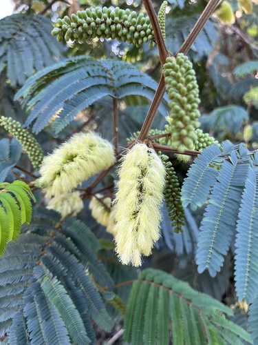
Paraserianthes lophantha
Cape Leeuwin wattle · also Bicol wattle, Cape wattle, Crested wattle
Report an issue with this species
This fast-growing, small to medium-sized tree features attractive feathery foliage and creamy-yellow, bottlebrush-like flowers, followed by large brown pea-like pods. It is drought tolerant and commonly planted as an ornamental due to its broad, spreading crown, prolonged flowering, and pest resistance. Although adapted to fire-disturbed landscapes, it is considered invasive in many regions outside its native range.
Where it grows
Trees in each city's inventory, with the share of that city's named trees this species accounts for.
- 30,6552.1%——
- 60.02%—6.5 in
- 20.00%—3.8 in
No city in this list records planting dates for this species, so age is blank throughout.
Traits
- Form
- Spreading
- Mature height
- 5–25 ft
- Canopy spread
- 10 ft
- Growth rate
- Fast
- Water needs
- Moderate
- Drought tolerance
- High
- Blooms
- Mar, Apr, May, Jun, Jul, Aug
Trunk diameters across every city: median 5.3 in, mean 6.9 in, 90th percentile 12 in. Measured at breast height, as published by each inventory.
Native range
Terrestrial ecoregions where this species is native. Trees in the dataset mostly stand well outside it.
Tropical & Subtropical Moist Broadleaf Forests
- Eastern Java-Bali montane rain forests
- Eastern Java-Bali rain forests
- Western Java montane rain forests
- Western Java rain forests
Mediterranean Forests, Woodlands & Scrub
- Southwest Australia savanna
- Southwest Australia woodlands
Tropical & Subtropical Dry Broadleaf Forests
- Lesser Sundas deciduous forests