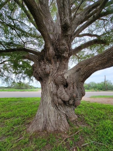
Taxodium mucronatum
Montezuma cypress · also Montezuma bald cypress, Sabino, Ahuehuete
Report an issue with this species
Taxodium mucronatum is a tall coniferous tree found in swamps, streams, and riparian habitats. It features a broad, buttressed trunk and weeping, bluish-green foliage. This long-lived species is drought tolerant and resistant to many pests and diseases.
Where it grows
Trees in each city's inventory, with the share of that city's named trees this species accounts for.
- 730.04%—16 in
- 320.01%36 yr13 in
- 60.00%54 yr—
- 30.00%—5.5 in
- 30.00%—12 in
Traits
- Form
- Conifer
- Mature height
- 50–130 ft
- Canopy spread
- 20–40 ft
- Lifespan
- 1500 years
- Water needs
- Moderate
- Drought tolerance
- Moderate
Trunk diameters across every city: median 15 in, mean 16 in, 90th percentile 22 in. Measured at breast height, as published by each inventory.
Native range
Terrestrial ecoregions where this species is native. Trees in the dataset mostly stand well outside it.
Tropical & Subtropical Moist Broadleaf Forests
- Central American Atlantic moist forests
- Central American montane forests
Temperate Broadleaf & Mixed Forests
- East Central Texas forests
Tropical & Subtropical Grasslands, Savannas & Shrublands
- Western Gulf coastal grasslands
Tropical & Subtropical Dry Broadleaf Forests
- Central American dry forests
Tropical & Subtropical Coniferous Forests
- Central American pine-oak forests
Other Taxodium in the catalogue
4 of the top 2,000 species are in this genus.

