#592 most planted
Acer monspessulanum
Montpellier maple · also French maple
Deciduous
971
trees mapped
0.01%
of all named trees
11
cities
3.3 in
median trunk (8 cm, 845 measured)
Report an issue with this species
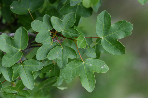
This tree can be distinguished from other maples by its small, three-lobed, dark, glossy green, and somewhat leathery leaves. It is native to the Mediterranean region and parts of Central Europe and Western Asia. It attracts birds.
Where it grows
Trees in each city's inventory, with the share of that city's named trees this species accounts for.
- 8370.37%—3.4 in
- 550.01%8.8 yr3.9 in
- 410.00%—1.6 in
- 270.01%4.8 yr5.9 in
- 30.00%—0.8 in
- 30.00%—23 in
- 10.00%—9.0 in
- 10.00%—2.0 in
- 10.00%—3.0 in
- 10.00%——
- 10.00%——
Traits
- Foliage
- Deciduous
- Mature height
- 15–35 ft
- Canopy spread
- 10–20 ft
- Growth rate
- Fast
- Wildlife value
- Moderate
- Blooms
- Mar, Apr, May, Jun, Jul, Aug
Trunk diameters across every city: median 3.3 in, mean 5.1 in, 90th percentile 8.8 in. Measured at breast height, as published by each inventory.
Native range
Terrestrial ecoregions where this species is native. Trees in the dataset mostly stand well outside it.
Temperate Broadleaf & Mixed Forests
- Balkan mixed forests
- Caucasus mixed forests
- Central European mixed forests
Mediterranean Forests, Woodlands & Scrub
- Aegean and Western Turkey sclerophyllous and mixed forests
- Northeast Spain and Southern France Mediterranean forests
Other Acer in the catalogue
50 of the top 2,000 species are in this genus.


